The Institute of Public & Environmental Affairs (IPE), a 2015 Skoll Awardee, is a pioneering NGO that developed the first public database of water pollution information in China and brought together a coalition of Chinese NGOs to push large corporations to focus on the environmental performance of their suppliers. On January 26, Chinese New Year, following the COVID-19 outbreak in Wuhan, IPE recognized the need for accurate, timely data displayed in a way that was easy for people to use.
IPE quickly redeployed its database and mapping infrastructure to track outbreaks and risk of outbreaks in real time, and to give government officials the granular data they needed to make science-based decisions. Two days of round-the-clock work gave birth to the IPE Epidemic Map.
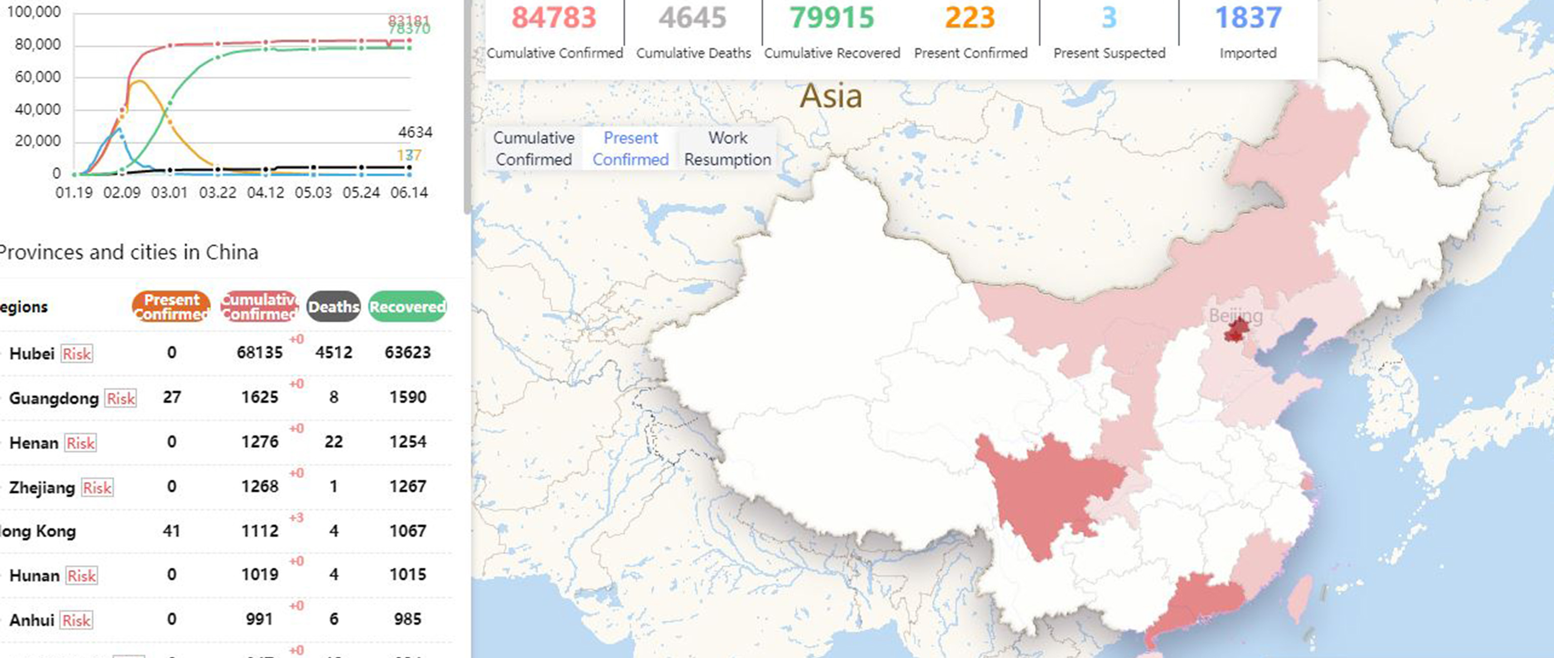
Collecting epidemic data from more than 2,000 districts, IPE classified, sorted, and developed a community outbreak map to help residents understand the severity of the outbreak on their local level, down to individual apartment complexes. For the first time scientists, government leaders, and Chinese citizens could track the numbers of reported coronavirus, where they were located, and the severity of the impact.
Website visitors can view data based on country, region, city, and district, tracking reports by cumulative confirmed cases, cumulative deaths, and cumulative cases recovered. Updates in near real-time reveal present cases confirmed and suspected as well as the number of cases imported from outside of China.
By February 2nd IPE was issuing daily reports on WeChat, Weibo, and its own Blue Map app. Since then, IPE has released seven major versions of the Epidemic Map which now chart trending data from around the world. New features now include a risk tracking function and a work resumption index to indicate which regions of the country are getting back to normal and presumed safe. As the epidemic abates in China, IPE now tracks data on a global basis.
At one week old, IPE’s Pandemic Map had recorded more than 100 million page views and hit a limit of 2 million simultaneous users. While citizens use the Pandemic Map as a vital source of safety information, government officials rely on data IPE gathers to help inform their scientific decision-making. From policy recommendations regarding quarantines and the deployment of medical resources, to identifying hotspots and recording new outbreaks of cases imported from overseas, the Epidemic Map created by the IPE has played a vital, and life-saving role in China’s public-safety response to the pandemic.
Want more stories of transformational change on the world’s most pressing problems? Sign up for Skoll Foundation’s monthly newsletter.